A Hillwalker’s Guide to Weather Fronts
How to read changing weather — quickly, simply, and confidently.
Weather fronts are the boundaries between two different air masses — warm vs cold, moist vs dry. When they move across the UK, they bring the classic changes you feel on the hill: rising wind, lowering cloud, rain bands, sudden clearances, and temperature swings.
Think of a front as a moving line of change. What matters to you is what’s coming next.
1. Cold Front — the “sharp change” front
What it is
Cold, dense air pushes underneath warm air, forcing it up. This creates fast‑moving, energetic weather.
What you’ll notice on the hill
- Wind picks up, often gusty
- Cloud builds quickly
- Showers or heavy rain arrive suddenly
- Visibility can drop fast
- Temperature falls sharply as it passes
After it passes
Clearer, colder air with good visibility — often the best walking of the day — but still showery behind the front.
Hillwalking takeaway
If a cold front is due mid‑walk, expect rapid changes. Plan escape routes, correct waterproofs and be ready for a short, sharp battering.
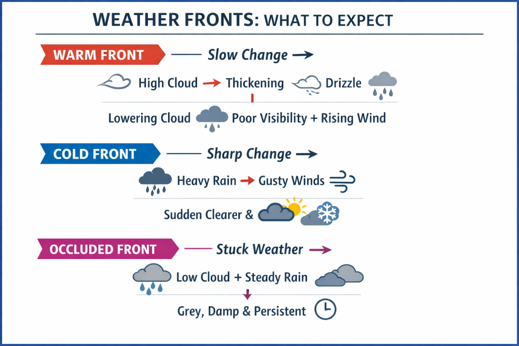
2. Warm Front — the “slow deterioration” front
What it is
Warm air glides up and over cold air, creating layered cloud and long‑lasting rain.
What you’ll notice on the hill
- High cloud thickens gradually
- Visibility slowly reduces
- Drizzle or steady rain sets in
- Cloud base drops… and keeps dropping
- Winds strengthen ahead of the front
After it passes
Milder but often grey, damp, and claggy.
Hillwalking takeaway
A warm front rarely surprises you — it slowly ruins the day. If it’s coming, start early or choose a lower‑level route.
When you spot that high, silky cirrostratus spreading across the sky, it’s often the first visual warning that a warm front and its rain band are on the way, typically within 6–12 hours or roughly 50–100 miles of travel.
3. Occluded Front — the “messy mix” front
What it is
A cold front catches a warm front, lifting the warm air off the ground. The result is mixed, stubborn, often miserable weather.
What you’ll notice
- Low cloud
- Persistent rain
- Poor visibility
- Little improvement for hours
Hillwalking takeaway
This is the classic clag day. If an occlusion is sitting over the Peaks, expect a slog.
4. Waving Front — the “stuck” front
What it is
A kink in a cold front that slows it down. Instead of clearing, it lingers.
What you’ll notice
- Rain that lasts all day
- No clean “front passes, then clears” moment
- Wind shifts but weather doesn’t improve
Hillwalking takeaway
If the forecast mentions a waving front, expect prolonged wetness. Choose waterproof morale.
How to Use This on the Hill
1. Watch the cloud base
Warm fronts lower it steadily. Cold fronts drop it suddenly.
2. Feel the wind shifts
Increasing wind usually means a front is approaching.
3. Look for “front sequences”
Warm front → drizzle → mild grey Cold front → heavy rain → sharp clearance
4. Use pressure charts
Fronts ride along pressure systems — the Met Office charts show them clearly.
5. Think in terms of timing
Fronts typically move west → east across the UK. If a front is due at 3pm, plan to be off the tops by 1.
Leader’s Tip: Hills Create Their Own Weather
Even when the forecast looks simple, remember that winds can push air masses up the slopes, forcing them to cool and condense. This can create localised cloud, sudden rain, or fast‑forming hill fog that doesn’t appear on the wider forecast. It’s why the tops can change faster — and feel very different — from the valleys below.